

Executive Summary
This case study provides an anecdotal description of a wildfire incident that impacted the Scotch Creek Community in British Columbia, Canada. The community was protected by a high-volume water delivery system. A wildfire run associated with the Bush Creek East Wildfire reached the community on August 18th, 2023. The run approached the community from the north and west. Using weather observations from the Calhity station and onsite observations, it was determined that a high intensity crown wildfire front and flank reached the community at approximately 17:30 that evening.
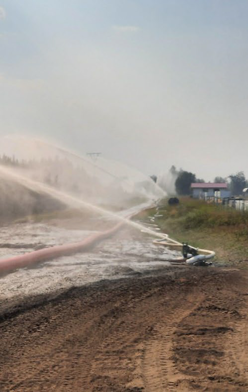
The high-volume water delivery system setup on the northern perimeter of the Scotch Creek Community consisted of 3 kilometers of 30 centimeter hose with 12 360o rotating water cannons supplied by 2 main 604 hp and 2 booster 604 hp pumps. The system had a flow rate of between 27,275 and 35,460 liters per minute. Each monitor had a reach of 180 meters and beyond depending on the wind direction and speed.
After the wildfire had passed the community on August 19th, 2023, significant structure losses were observed on the west side of the community outside of the protection area of the high-volume system with no structural loss in the primary protection zone and minimal losses in the secondary protection zone.
It is clear that the high-volume system protected the primary zone from direct impingement from a high intensity (Intensity Class 4-6) crowning wildfire. It is highly probable that given fuel continuities north to south the halting of the fire front minimized the impact of the fire in the secondary zone. The impact of the water delivery system on ember showers from the fire front is difficult to value but it is likely it had some impact in the secondary zone. Fire spread from the west on the southern end of the community was likely influenced by other factors such as a change in fuel type and the actions of shelter in place residents.
Introduction
This case study is an anecdotal description of the effect of a high-volume water delivery system on the wildfire behaviour observed on the Scotch Creek Community during a wildfire run on August 18th, 2023. The study relies on off-site measurements of wildfire behaviour (satellite imagery) and weather, fire behaviour predictions, as well as visual observations of staff that were on site to construct a description of wildfire behaviour. The case study focuses on the impact that the values protections system had on wildfire behaviour as the wildfire reached the community.
Location
The Scotch Creek Community is one of a series of unincorporated communities located along the north shore of Shuswap Lake in the Thompson Okanagan region of British Columbia (BC), Canada. The community lies 28 km east of Chase which is located on the TransCanada Highway. The Scotch Creek Community falls under the jurisdiction of the Columbia Shuswap Regional District (Figure 1).
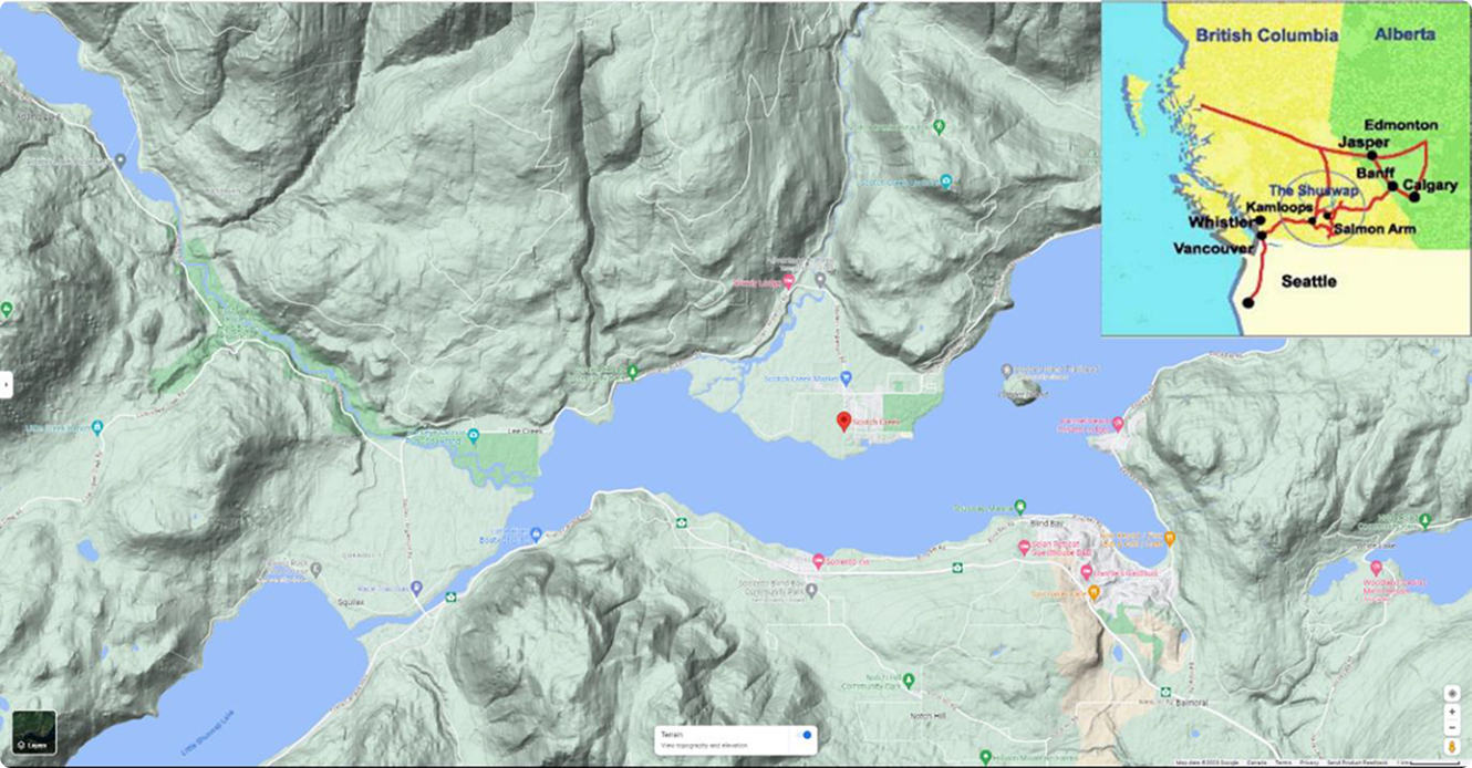
The wildfires that impacted the Scotch Creek Community were the Lower Adams Lake Wildfire (K21620) and the Bush Creek East Wildfire (K21633) that were discovered on July 12th, 2023. The causes of both wildfires are suspected to be lightning. The two wildfires grew together to become the Bush Creek East Wildfire before impacting the community. The approximate start locations of the wildfires are shown in Figure 2.

2023 Wildfire Seasonal Overview
During the 2023 wildfire season British Columbia and much of Western Canada was experiencing significant drought. Figure 3 shows that the majority of the province was significantly impacted by a multi-year drought at the time of the wildfires run on August 18th.
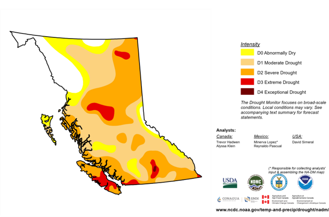
The lack of overwinter precipitation and lower than average spring and summer precipitation had resulted in an extreme wildfire season. By mid-August B.C. had already seen historically high area burned. All provinces and territories in Canada, with the exception of Manitoba and Nunavut, had a very busy spring wildfire season that extended in the summer in Alberta, Northwest Territories, Saskatchewan and Quebec. Canadian wildfire management agencies rely on the exchange of resources such as personnel, equipment and aircraft, from other provinces, territories and countries through long established mutual aid agreements. During the wildfire season of 2023 record numbers of resources were exchanged with B.C. from across the world.
Despite the influx of wildfire management resources B.C. was still taxed with large active wildfires, regular new wildfire starts and continued dry and windy weather. At the time of the Bush Creek East wildfire run many adjacent municipalities were impacted and response resources were limited.
August 16th – 17th, 2023
Leading into August 16th the wildfires remained active on the upper slopes in the Adams Lake area approximately 15 kilometers to the northwest of the Scotch Creek Community. The wildfires took significant runs moving past containment features and spread north to south on August 16th and August 17th. The approximate location of the wildfire front on August 17th is shown on a satellite thermal detection map using the Wildfire Information for Resources Management System (FIRMS) in Figure 4.

Based on this wildfire spread and forecasted weather Fire & Flood Emergency Services Limited was deployed by the B.C. Wildfire Service (BCWS) on August 17th to preplan deployment of a high-volume water delivery system at the Scotch Creek Community.
Antecedent Weather and Wildfire Behaviour Conditions
Values used to describe weather and wildfire behaviour parameters are in metric and based on the Canadian Forest Fire Danger Rating System (CFFDRS). Hourly Weather data is from the Cahilty weather station (BC Government) located at 50’.8883 N 119’8383 W. The station is 27km west of the Scotch Creek Community and is 1200m in elevation above the community. Start-up values for the Fire Weather Indices (FWI) were obtained from the Canadian Forest Service – Canadian Wildland Wildfire Information System. All times are in Pacific Daylight Savings Time (-7 GMT). All data and information are from public sources.
Table 1: Weather Conditions for August 17 at 13:00
| Date | Time | Temp | RH | Precip. | Wind Sp. | Wind Dir. |
|---|---|---|---|---|---|---|
| August 17 | 13:00 | 28.9 | 28 | 0.0 | 9.1 | 244 (WSW) |
On August 17th a period of drying under an upper air ridge had resulted in extreme Fire Weather Indices (FWI).
Table 2: Wildfire Weather Indices for August 17 at 13:00
| Date | FFMC | DMC | DC | ISI | BUI | FWI |
|---|---|---|---|---|---|---|
| August 17 | 90.8 | 86.4 | 563.7 | 12.5 | 9 | 40.1 |
The Fine Fuel Moisture Content (FFMC) is an indicator of the moisture content of fine fuels such as grass and litter on the surface of the forest floor. The Duff Moisture Content (DMC) is an indicator of the moisture for larger fuels like branches and organic soil layers below the surface. The Drought Code (DC) is an indicator of large fuels such tree trunks and deeper organic soil layers. The Initial Spread Index (ISI) is an indicator of wildfire intensity (Kilowatt/meter of wildfire front) and how fast a wildfire will move in fine fuels based on FFMC and wind. The Build Up Index (BUI) is an indicator of how much larger fuels are available to burn and the severity (how deep and long a wildfire will burn) based on DMC and DC. The Fire Weather Index (FWI) is an overall indicator of intensity and severity of wildfire conditions based on ISI and BUI. All indices were extreme on August 17th. Wildfire behaviours to be expected under these indicies include fast moving continuous crown fires with very high intensities and severity that would be beyond the capabilities of ground crews and most types of air attack.
Forest fuels in the area were a mix of Douglas Fir, Lodgepole Pine, White Pine and Cedar stands. These fuel types are best represented by the CFFDRS Fuel types; C-7 Ponderosa Pine – Douglas Fir, C-3 Mature Jack or Lodgepole Pine and C-4 Immature Jack or Lodgepole Pine. The site of the Scotch Creek Community lies on an alluvial fan that is generally flat surrounded by steep mountain ridges to the northwest and northeast.
The forecast for August 18th was for an upper air ridge to be replaced by an upper trough moving in from the west. Accompanying the trough was a surface low pressure feature with accompanying dry cold front that passed through the Scotch Creek area on August 17th and brought strong north to northwest winds with no precipitation. The strong northerly winds were expected to continue on August 18th for most of the day with low relative humidity (RH) and poor overnight recovery of RH overnight. This combination of dry conditions and strong prolonged winds was expected to result in extreme wildfire behaviour throughout the day and into the night. With the prevailing synoptic winds and topographic channeling of the wind field expected wildfire growth was from the North-West to the South-East.
August 18th – Predicted Wildfire Behaviour
On the morning of August 18th, temperatures were moderate and overnight RH recovery was poor, winds at ridge tops were increasing and mixing lower onto the valley floor from the North. Hourly weather measurements for August 18th are provided in Appendix 1.
Table 3: Weather Conditions for August 18th at 06:00
| Date | Time | Temp | RH | Precip. | Wind Sp. | Wind Dir. |
|---|---|---|---|---|---|---|
| August 18 | 06:00 | 10.7 | 51 | 0.0 | 11.3 | 317 (NW) |
The weather forecast that day was for increasing winds from the north and dropping RH with no precipitation. The wildfire behaviour was expected to be aggressive even on downhill runs.
Table 4: Wildfire Weather Indices for August 18th at 13:00
| Date | FFMC | DMC | DC | ISI | BUI | FWI |
|---|---|---|---|---|---|---|
| August 18 | 90.1 | 88.3 | 569.2 | 11.4 | 127.2 | 39 |
Calculated Wildfire Behaviour
Table 5: Wildfire Behaviour Outputs for August 18th at 17:00
| Fuel Type | ROS (m/min) | HFI (kW/m) | CFB | Head Wildfire | Flank Wildfire | Intensity Class |
|---|---|---|---|---|---|---|
| C-4 | 20 | 29, 850 | 99% | Crown | Int Crown | 6 |
| C-3 | 10 | 13,044 | 70% | Int Crown | Surface | 6 |
| C-7 | 5 | 29, 850 | 0% | Crown | Surface | 4 |
August 18th Chronology
Table 6: Chronology of Events August 18th, 2023.
| Time | Observation |
|---|---|
| 0530 | Crew onsite – Briefings and organization. Wildfire visible to northwest |
| 0630 | Crew begins deployment – Line location, equipment mobilization and deployment. |
| 1355 | Photo 2+3: Wildfire Behaviour to the north and west from Co-Op Cardlock. |
| 1626 | Photo 4: Wildfire Behaviour to the north from Co-Op Cardlock. |
| 1630 | System deployed to extent possible and activated (Figure XX) |
| 1724 | Photo 5: Wildfire front reaches values protection line. |
| 1815* | Travel east from Community reveals wildfire front had reached road and structures. |
| 2046 | Crew ordered to evacuate by BC Wildfire Service Structure Protection Specialist. |
| 2056 | Crew mobilized and moving west. |
| 2100 | Video showing structure involvement on west side of Squilax-Anglemont Road. |
| 2139 | Crew clear of wildfire perimeter on TransCanada Highway headed west to Kamloops |
All observations made by Derek Sommerville, Fire & Flood Emergency Services, Ltd. *Approximate time – somewhere between 1800-1830
August 18th – High Volume Water Delivery System Setup
Fire & Flood Emergency Services Ltd. established a main water delivery line comprised of 30 cm diameter hose sections over an approximately 3 km run length. The line utilized 12 water cannons with a spray radius of 180m spraying over 360o. Given the diameter of each cannon, the total area impacted by the water delivery would equal approximately 36 hectares. It was noted by onsite staff that given wind direction and velocity there was significant downwind impact from water delivery. This was evidenced by the wet pavement observable in Photo 1. The line was strategically located to enable overlapping coverage along the northern perimeter of the Scotch Creek Community. The system was supplied by two 604 hp main pumps in parallel drawing water from Shuswap Lake and two 604 hp booster pumps located approximately halfway along the hose line. The system is estimated to have delivered 27,275 – 35,460 litres per minute. Using the more conservative value of 27,275 litres and the one hour run time that was realized between system start and the wildfire front arrival the system would have delivered 1.6 million liters of water. It is worth noting that delivering this volume of water in a short span of time is not the normal operating procedure with the system. Typically, water is delivered intermittently over longer periods of time to enable penetration into fuels and to reduce the risk of any negative impacts such as water pooling. The high-volume water delivery setup is shown in figure 5.

August 18th – Observed Wildfire Behaviour
The wildfire behaviour observed when the Fire & Flood team were first onsite August 18th at 05:30 was consistent with a morning inversion with light winds and heavy smoke. Initial observations at 05:30 had the wildfire established west of Scotch Creek on the ridge well above the road. The fire front was difficult to pinpoint given smoky conditions. Winds gradually picked up through the day as recorded by the Cahilty weather station with the strongest sustained winds of 19km/h recorded at 13:00. Onsite observations described the general winds from the NW with local winds more westerly. Figure 6 shows approximate observed wildfire fronts on August 18th.

Based on Photo 2 taken at 13:55 the wildfire front has likely crossed Scotch Creek and is on the north side of the ridge above the community. This is supported by Photo 3 taken looking west which indicates that the fire is approaching from the west. It is not possible to determine if it has breached Scotch Creek to the west of the Community, but it is clear based on smoke colour that it is active to the west.
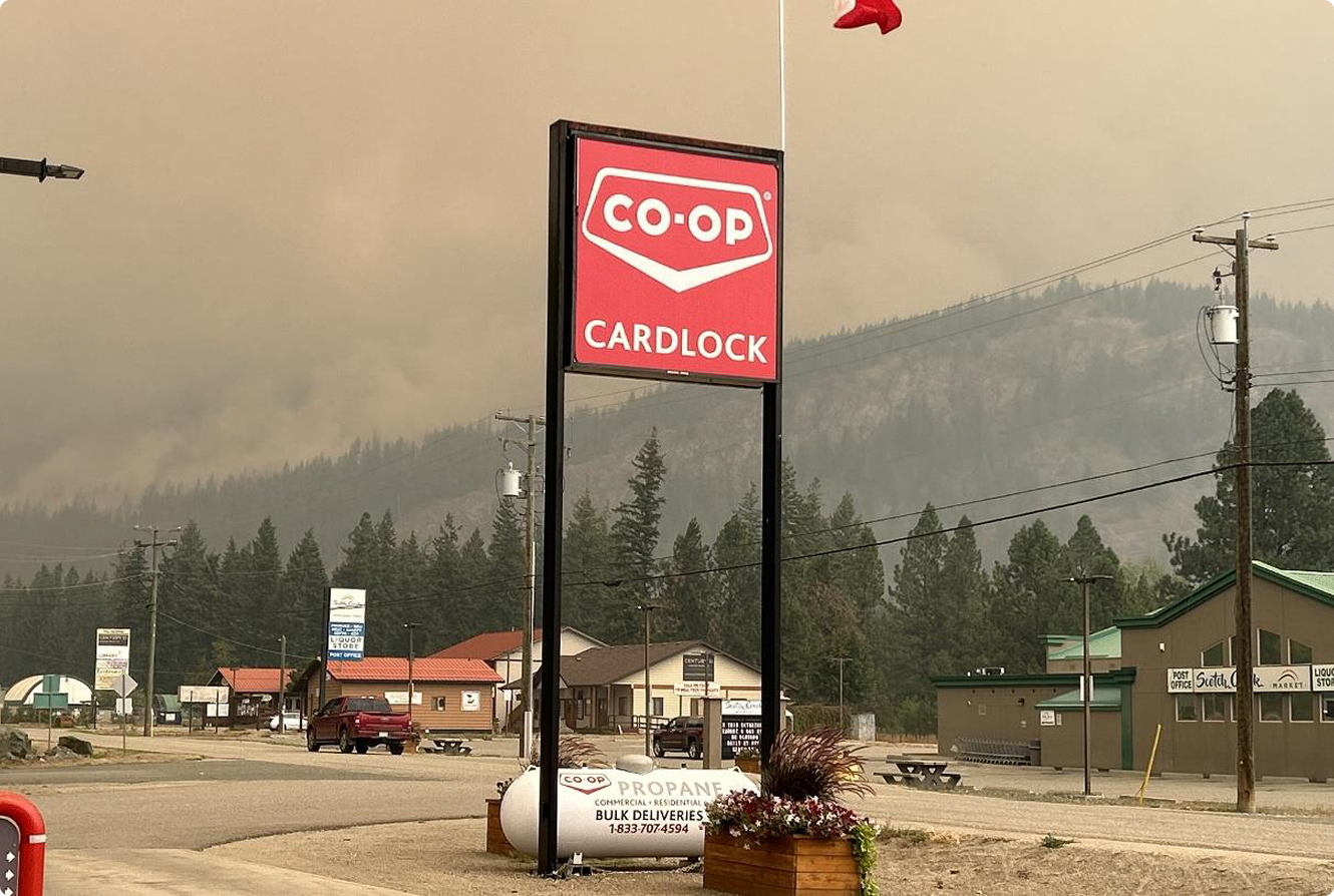

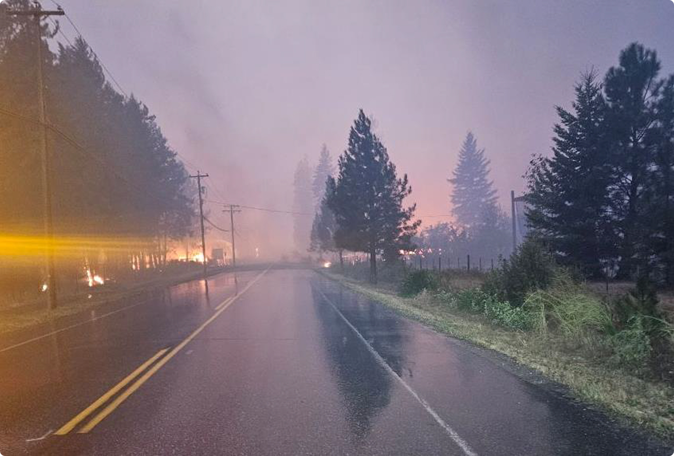
On site, Derek Sommerville estimated winds to be variable to 25 km/h, westerly to northerly with gusts up to 40km/h at 16:30. As the smoke cleared in the afternoon, Derek was able to directly observe the wildfire front as it approached the water delivery system line. At 16:30 Derek observed crown wildfire running eastward from the top of the ridge north of town with a flanking wildfire backing down the slope. Flame lengths were 9m above 30m tall trees indicating very high wildfire intensities. The colour of the smoke was black to bronze in a well-defined convective column indicating intense incomplete combustion. The wildfire was estimated to be 1km from the value protection line which would reach the line in 20 to 40 minutes. These observations are supported by Photo 4. The front is reported to have reached the water delivery system at 17:24 as supported by Photo 5. Of note in this photo is that the fire has spotted along the ridge well to the east.


The final observation of the west to east progression of the fire front is provided when Derek attempts to drive east at approximately 18:15 and observes the front across the road at the junction of the Squilax-Anglemont Road and Cliffside Road approximately 500 metres east of the area the water delivery system was deployed.
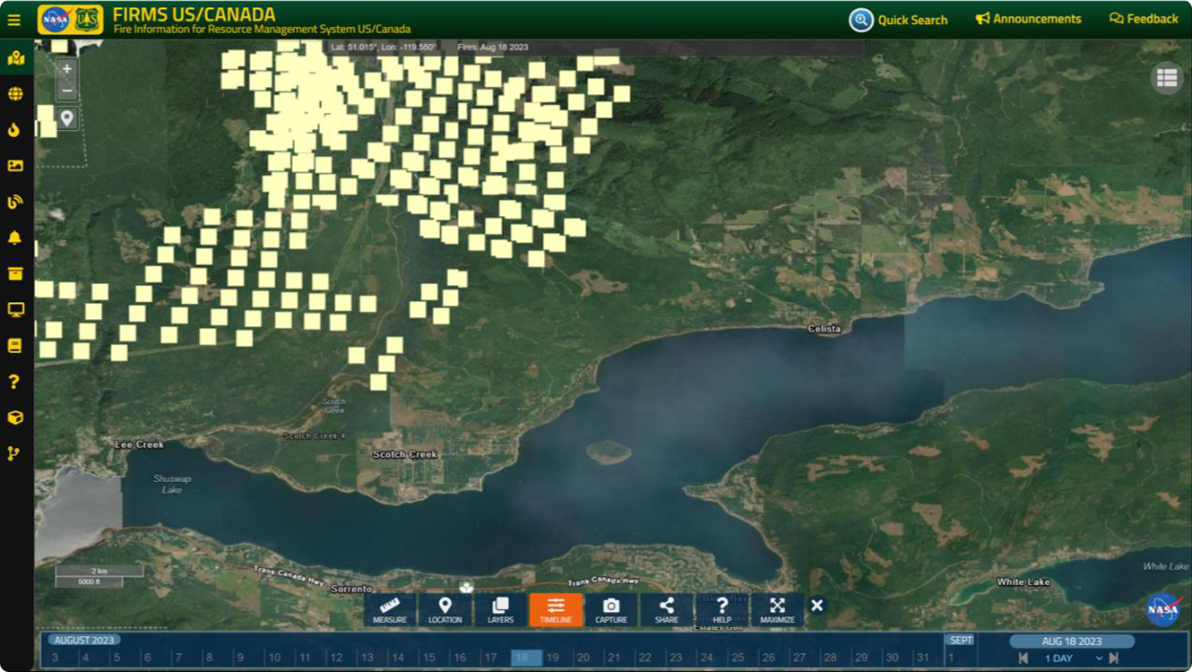
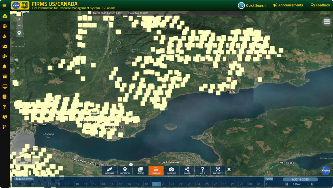
Upon evacuating at 20:56 the crew was directed to leave the system running and did so. There was no formal fire suppression resources remaining on scene however it is thought that shelter in place residents remained active. The Fire & Flood team returned on August 19th at approximately 15:00 and to their knowledge they were the first formal suppression resource in the area. When the team returned the system was still running having been fueled by residents who chose to shelter in place. They observed no structure loss between the values protection line and the Squilax-Anglemont Road to the south and west. There were 3 old barn structures lost just east of where the Squilax-Anglemont Road shifts from running west-east to north-south. Immediately south of that location on the south side of the road a local business lost structures and property in a supply yard. Figure 7 shows the approximate extent of the wildfire front based on FIRMS data on August 19th. Appendix 2 shows the approximate location based on FIRMS data of the wildfire front from August 18th to 19th.


August 18th Summary
The wildfire run that affected the Scotch Creek Community occurred over approximately 4 hours from 14:00 to 18:00. The run moved downslope from the northwest side of Scotch Creek, crossed the creek and ran in a west to east down sloping pattern. The calculated and observed wildfire behaviour are in agreement with a crowning head wildfire of Intensity Class 6 and an intermittent crowning flank wildfire of Intensity Class 4 directly impinging the western and northern most extent of the water delivery system at approximately 17:30. The water delivery system line halted the fire at the northern community perimeter and did not allow impingement.
Discussion
Given the nature of this report a detailed assessment of structure loss was not completed or considered. The following provides a general summary of the impacts of the wildfire on the community. Figure 8. provides a visual support to the discussion.
The area to the west of the Squilax-Anglemont Road was heavily impacted by fire impinging from the north and west (red perimeter in figure 8, photo 6). This resulted in substantive structure loss and is consistent with an intensity class 6 wildfire impinging on structures in an interface scenario. The area within the primary zone of protection of the water delivery system (blue perimeter) was unimpacted by the wildfire either through impingement or ember shower. The area south and east of the primary zone of protection (orange dotted perimeters) suffered no known structure loss with the exemption of the small area that occurred at a local business supply yard.
Structure loss in the secondary protection areas to the south and east of the primary protection area was minimal with only two known structures lost in the southeast corner of the southern zone. It is difficult to determine the impact of the water delivery system in this area, however it is clear that the water delivery system halted direct impingement from the north. Given the continuity of forest fuels from north to south it is felt by the authors that were the wildfire to have breached the community in the north it would have had a substantive impact on community areas to the south and east of the Squilax-Anglemont Road. Given reports onsite of substantive ember shower, which would be consistent with a fire of this intensity, it is unclear how this did not result in more ignition in the secondary zone. Even with the substantive wind drift of water from the delivery system noted by onsite staff the downwind impact of this over the approximately 1 km distance from the Squilax-Anglemont Road is unlikely. The effect of the shelter in place residents is unknown but may have had an impact in minimizing the impact of ember shower through the southern areas of the community which were likely under minimal influence of drift from the water delivery system.
Another avenue of potential wildfire growth that remains unassessed is the front that moved into the southwestern area of the community from the west. It is unclear as to why fire moving west from Scotch Creek did not have more impact on the community. The fuel assembly immediately to the west of the Scotch Creek Wharf road is comprised of sparse immature forest fuels combined with open fuel types.
Fire suppression efforts in these fuel types would have impacted fire spread. These suppression efforts may have occurred from shelter in place individuals.
Conclusion
The water delivery system established by Fire & Flood Emergency Services, Ltd on August 18th halted the direct impingement of a Intensity Class 4-6 wildfire approaching the Scotch Creek Community from the north and west. The 3 km long system was established in 10 hours and delivered 1.6M liters of water over the one hour run time it ran before fire impingement. While the downwind impacts of this protection are less clear it is likely that the system played a substantive role in protecting the areas to the south and east of the primary protection area.
Appendix 1: Hourly Weather Observations Cahilty Station for August 18, 2023
| Date | Time | Temp | RH | Precip. | Wind Sp. | Wind Dir. |
|---|---|---|---|---|---|---|
| August 18 | 0:00 | 15.1 | 65 | 0.0 | 5.6 | 293 |
| August 18 | 1:00 | 13.8 | 72 | 0.0 | 4.7 | 314 |
| August 18 | 2:00 | 13.7 | 62 | 0.0 | 5.5 | 302 |
| August 18 | 3:00 | 12.5 | 48 | 0.0 | 10.1 | 336 |
| August 18 | 4:00 | 11.8 | 49 | 0.0 | 12.1 | 316 |
| August 18 | 5:00 | 10.5 | 50 | 0.0 | 12.4 | 322 |
| August 18 | 6:00 | 10.7 | 51 | 0.0 | 11.3 | 317 |
| August 18 | 7:00 | 13.2 | 46 | 0.0 | 5.3 | 296 |
| August 18 | 8:00 | 11.5 | 52 | 0.0 | 10.1 | 296 |
| August 18 | 9:00 | 13.1 | 42 | 0.0 | 18 | 323 |
| August 18 | 10:00 | 13.7 | 45 | 0.0 | 16.8 | 297 |
| August 18 | 11:00 | 14.4 | 44 | 0.0 | 17.3 | 295 |
| August 18 | 12:00 | 14.3 | 38 | 0.0 | 13.9 | 289 |
| August 18 | 13:00 | 13.8 | 39 | 0.0 | 19 | 299 |
| August 18 | 14:00 | 14.6 | 37 | 0.0 | 18.1 | 309 |
| August 18 | 15:00 | 14.6 | 35 | 0.0 | 14.7 | 301 |
| August 18 | 16:00 | 13.7 | 39 | 0.0 | 12.4 | 299 |
| August 18 | 17:00 | 11.2 | 48 | 0.0 | 11.4 | 316 |
| August 18 | 18:00 | 8.6 | 59 | 0.0 | 4.7 | 343 |
| August 18 | 19:00 | 6.5 | 68 | 0.0 | 3.5 | 337 |
| August 18 | 20:00 | 5.1 | 71 | 0.0 | 4 | 330 |
| August 18 | 21:00 | 4.2 | 78 | 0.0 | 3.7 | 341 |
| August 18 | 22:00 | 4.1 | 72 | 0.0 | 5.4 | 318 |
| August 18 | 23:00 | 4.4 | 74 | 0.0 | 7.7 | 320 |
Appendix 2: FIRMS imagery showing the approximate wildfire front progression – August 17-19
Wildland Fire Works Consultants who authored this report were:
Mike Etches – Forty years of experience in managing wildland fires at the crew, Duty Officer, Incident Management Teams and executive management levels. Mike’s focus includes tactical and strategic planning, the Planning Section Chief function and Team Development
Rick Kubian – Forty years of experience in managing landscape wildland fires in protected areas, prescribed fire, Duty Officer. Incident Management teams and executive Management. Rick’s focus includes tactical and strategic planning, the Incident Commander function and Team Development.
The contents of this report are the intellectual property of Wildland Fire Works. You may not reuse, republish, or reprint such content without our prior written consent.
All information provided is for informational purposes. Should you decide to act upon the information in this report, you do so at your own risk.
While the information in this report has been verified to the best of our abilities, we cannot guarantee that there are no mistakes or errors.